
Take A Scenic Drive From Cody To Yellowstone
Jan 112021_0_o.jpg)
The year is 1877, Chief Joseph and the Nez Perce have been fighting off the US cavalry for months in an attempt to reach asylum in Canada. Escaping Yellowstone, they enter the Absaroka Mountains and descend into Sunlight Basin, desperately making their way north towards the border.
Nearly thirty years later in the valley below, construction begins on an innovative irrigation proposal, one that will transform the Bighorn Basin into the fertile agricultural land that it is today. Both tales help paint the picture of the northwest Wyoming landscape we call home. To date countless travelers have followed their legacies on the scenic byways dedicated to these historic figures: Chief Joseph Scenic Highway (WYO 296) and Buffalo Bill Scenic Byway (US 14-16-20).
For up to date information on how to get to Yellowstone, we recommend calling their road report line at 307-344-2117. You can check road openings and closures by visiting their website at https://www.nps.gov/yell/planyourvisit/parkroads.htm.
Jump to Section:
_0_o.jpg)
Cody WY As Base Camp
Cody Wyoming is a longstanding destination amongst Yellowstone travelers and outdoor recreation enthusiasts. Cody's many attractions draw thousands here each year, but for those seeking more, there are two renowned scenic byways that begin their route just outside of town. Chief Joseph Scenic Highway and Buffalo Bill Scenic Byway are easily done in a day’s time, and from May-October consider combining the two in an indulgent loop through Yellowstone National Park. Locals and tourists alike can take delight in breathtaking views and captivating nuggets of history learned by following these two scenic byways beginning right here in Cody Wyoming.
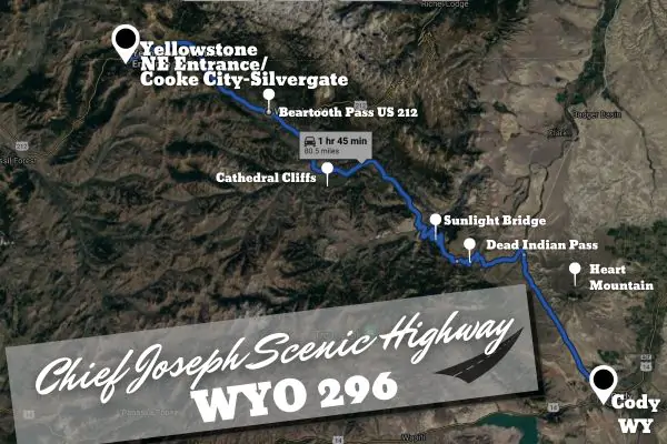
Chief Joseph Scenic Highway
WYO 296 | open year-round | 46 mi | 74km | 1.5-2 hours
Though the Chief Joseph Scenic Highway is open year-round, you can only visit Yellowstone from Cody via Cooke City-Silvergate and the Northeast Entrance from May-October, when the Beartooth Pass is open. Check the National Park Service website for road openings and closures.
What You Can Expect:
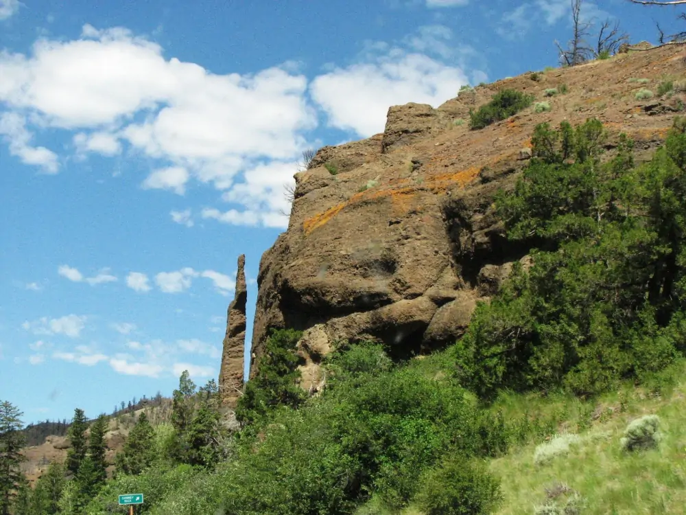
Sweeping vistas from the top of the pass, red rock cliffs, and waterfalls, with steep grades and switchbacks along the road. As you drive, you'll find opportune pullouts for scenic views and rich context via the highway historical markers sprinkled like breadcrumbs along the way.
Follow the story of Chief Joseph and the remaining Nez Perce in their admirable effort to escape the US cavalry and a future bound by reservation borders. The Nez Perce were unable to cross into Canada and attain asylum, ultimately surrendering just 40 miles from the border in 1877. The eponymous Chief Joseph Scenic Highway trails their escape route through the Absarokas and Shoshone National Forest. *Before embarking on the drive, remember to fill up the gas tank, and be advised that vehicles over 40 feet long are not recommended.
_0_o.jpg)
The Route:
From Cody, make your way to WYO 296 via 120, passing by Heart Mountain to the east. Once on the Chief Joseph Scenic Highway, you will begin to follow Blaine creek into the Absaroka Mountains until you make your way up the winding road to Dead Indian Pass (8,070 ft). From the pass, you'll be treated with a panoramic view looking ahead into Sunlight Basin.
The road continues down switchbacks and hairpin turns towards Sunlight Creek Bridge, the highest bridge in Wyoming! Make sure to stop at the pullout here to view the Sunlight Gorge, a steep drop at 1,200 ft deep. Back in the car, follow along the Clark's Fork of the Yellowstone River, bending around the mountains to take you just under the Cathedral Cliffs. Continue into the rugged canyon towards US HWY-212, the Beartooth pass, towards Cooke City-Silver Gate to access Yellowstone National Park via the NE entrance.
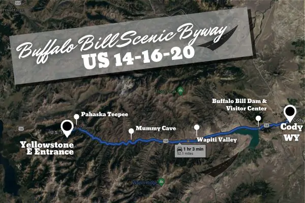
Buffalo Bill Scenic Byway
US 14/16/20 | Open year-round | 27mi | 44km | 45 mins-1hr
This scenic drive is open year-round and will take you from Cody WY to the Yellowstone East Entrance (when the entrance is open from May-November). Check the National Park Service website for road openings and closures.
_0_o.jpg)
What You Can Expect:
Awe-inspiring rock formations, and landscapes abundant with wildlife - elk, grizzly, bighorn sheep, antelope, moose, and deer. The drive will take you from one remarkable location to the next, starting at the Buffalo Bill Dam. Built in 1905, the dam transformed the Bighorn Basin into nearly 100,000 acres of productive agricultural land. At the time it was the tallest dam in the world and touted as an exemplary success of modern day engineering.
The byway will take you to another entrepreneurial venture of Buffalo Bill Cody, the historic Pahaska Teepee hunting lodge. The two story log building was built in 1903, and was originally constructed to serve travelers on "The Old Cody Road" to Yelllowstone. Now on the National Registrar of Historic Places, the area still serves as a place of respite for the road weary en route to Yellowstone.
The Route:
From Cody, make your way on US-14, following the Shoshone River through the canyon, passing under Cedar Mountain and Rattlesnake Mountain. Emerging from the final of three tunnels, you'll get your first glimpse of the Buffalo Bill Reservoir. Stop at the visitor’s center to learn more about this engineering marvel, along with the town flooded under the reservoir.
Continuing past the dam and state park, you'll trace the riverbends of the North Fork of the Shoshone through Wapiti Valley. Under the snow-capped peaks of the Absarokas, wildlife such as bighorn sheep and wapiti (elk) can be found grazing in their shadows. Just past the Rex Hale campground and a short hike from the road, you can view the cave of "Mummy Joe" ( a 1,200 year old mummified remains discovered by Cody resident Gene Smith and excavated by another, Bob Edgar).
Once through the valley and in the Shoshone National Forest, travel through swaths of thick forest, meadows, and exposed rock. Up above, scope out rock formations and hoodoos such as the Holy City, Goose Rock, and Chimney Rock. Stop at historic Pahaska Teepee to stretch your legs and top off your gas tank before traveling the final few miles to the East Entrance of Yellowstone National Park.
Read Related Articles:
Opening of Yellowstone
Chief Joseph and Sunlight Basin
Spring Trip To Yellowstone
Arrival of Spring
For up to date information on how to get to Yellowstone, we recommend calling their road report line at 307-344-2117. You can check road openings and closures by visiting their website at https://www.nps.gov/yell/planyourvisit/parkroads.htm.
Follow Us On: Facebook | Instagram